
Lancashire Holiday Lets's Guidebook
Sightseeing
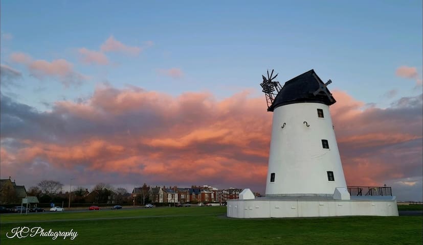
Haigh Woodland Park is the north west's best adventure park. High Ropes, Adventure Golf, Kitchen Courtyard and much more.
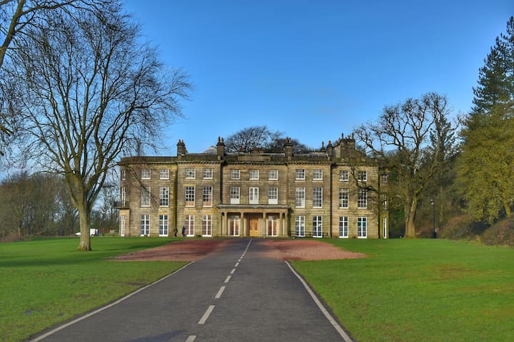
Haigh Woodland Park
School LaneHaigh Woodland Park is the north west's best adventure park. High Ropes, Adventure Golf, Kitchen Courtyard and much more.
Neighbourhoods
Chorley is a town in Lancashire, England, 8.1 miles north of Wigan, 10.8 miles south west of Blackburn, 11 miles north west of Bolton, 12 miles south of Preston and 19.5 miles north west of Manchester. The town's wealth came principally from the cotton industry.
Population: 38,420 (2016)
Colleges and universities: Albany Academy
Nearby airports: Manchester Airport · Liverpool John Lennon Airport
Nearby hospital: Chorley Hospital
History:
The name Chorley comes from two Anglo-Saxon words, ċeorl and lēah, probably meaning "the peasants' clearing". Ley (also lēah or leigh) is a common element of place-name, meaning a clearing in a woodland; ċeorl refers to a person of status similar to a freeman or a yeoman.
Prehistory:
There was no known occupation in Chorley until the Middle Ages, though archaeological evidence has shown that the area around the town has been inhabited since at least the Bronze Age. There are various remains of prehistoric occupation on the nearby Anglezarke Moor, including the Round Loaf tumulus which is believed to date from 3500 BC.
A pottery burial urn from this period was discovered in 1963 on land next to Astley Hall Farm and later excavation in the 1970s revealed another burial urn and four cremation pits dating from the Bronze Age.
Roman period:
During the Roman era a Roman road ran near Chorley between Wigan and Walton-le-Dale. Hoards dating from the Roman period have also been found at nearby at Whittle-le-Woods and Heapey.
Medieval period:
Chorley was not listed in the Domesday Book of 1086, though it is thought to be one of the twelve berewicks in the Leyland Hundred.
Chorley first appears in historical records in the mid thirteenth century as part of the portion of the Croston Lordship acquired by William de Ferrers, Earl of Derby, around 1250. The Earl established Chorley as a small borough comprising a two-row settlement arranged along what later became Market Street. It appears that the borough was short lived, as it does not appear in a report of a commission on the Leyland Hundred in 1341. It is most likely that the borough was sacked by the Scots during the Great Raid of 1322, with Chorley being one of the southernmost points reached in Northern England. This led to the construction of a Peel tower, which said to have been located somewhere close to Duxbury Hall.
The manorial history of Chorley is complex as the manor had no single lord throughout most of this period, as it had been split into moieties and was managed by several different families. This led to Chorley having several manorial halls, which in this period included Chorley Hall, built in the 14th century by the de Chorley family, which has since the 19th or 20th century been demolished. Very little is known of Chorley Hall, although according to what the painter John Bird painted in 1795, its location to where it once stood is said to have been where The Parish of St. Laurence Church of England Primary School now stands. There is also Lower Chorley Hall, which was owned by the Gillibrand family from 1583 (later rebuilt in the 19th century as Gillibrand Hall). It is believed the borough of Chorley was not a success in this period because of the lack of manorial leadership and the dispersed nature of the small population.
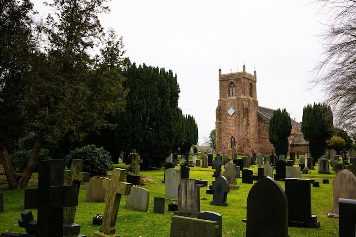
St Laurence's Church is the oldest remaining building in Chorley and first appears in historical records when it was dedicated in 1362, though it is believed there was already an earlier Anglo-Saxon chapel on the site which was a daughter foundation of Croston Parish Church. It is believed that the church is named after Saint Laurence, an Irish saint who died in Normandy in the 12th century, whose bones were conveyed to the church by local noble Sir Rowland Standish Duxbury, an ancestor of Myles Standish (an English military officer hired by the Pilgrims as military adviser for their Plymouth expedition to the New World).
As happened in many other instances following the Dissolution of the Monasteries, these relics went missing in the turmoil of the English Reformation under the rule of Henry VIII.
A market was held every Tuesday in Chorley and a fair was held annually on the feast of St Lawrence since 1498.
19th century to present:
Chorley, like most Lancashire towns, gained its wealth from the Industrial Revolution of the 19th century which was also responsible for the town's growth. Chorley was a vital cotton town with many mills littering the skyline up to the late twentieth century. Most mills were demolished between the 1950s and 2000s with those remaining converted for modern business purposes. Today only a minority remain in use for actual manufacturing, and the last mill to stop producing textiles was Lawrence's in 2009.
Also, given its location on the edge of Lancashire Coalfield, Chorley was vital in coal mining. Several pits existed in Duxbury Woods, the Gillibrand area and more numerously in Coppull. Chisnall Hall Colliery at Coppull was considered the biggest Lancashire pit outside of Wigan and one of many located in the Chorley suburb. The last pit in the area to close was the Ellerbeck Colliery in 1987 which was located south of Chorley, between Coppull and Adlington.
The town played an important role during the Second World War, when it was home to the Royal Ordnance Factory, a large munitions manufacturer in the village of Euxton about 2 miles (3 km) from the town centre. A smaller factory was also built near the railway line of Blackburn–Wigan in Heapey
8 persone del luogo consigliano
Chorley
Chorley is a town in Lancashire, England, 8.1 miles north of Wigan, 10.8 miles south west of Blackburn, 11 miles north west of Bolton, 12 miles south of Preston and 19.5 miles north west of Manchester. The town's wealth came principally from the cotton industry.
Population: 38,420 (2016)
Colleges and universities: Albany Academy
Nearby airports: Manchester Airport · Liverpool John Lennon Airport
Nearby hospital: Chorley Hospital
History:
The name Chorley comes from two Anglo-Saxon words, ċeorl and lēah, probably meaning "the peasants' clearing". Ley (also lēah or leigh) is a common element of place-name, meaning a clearing in a woodland; ċeorl refers to a person of status similar to a freeman or a yeoman.
Prehistory:
There was no known occupation in Chorley until the Middle Ages, though archaeological evidence has shown that the area around the town has been inhabited since at least the Bronze Age. There are various remains of prehistoric occupation on the nearby Anglezarke Moor, including the Round Loaf tumulus which is believed to date from 3500 BC.
A pottery burial urn from this period was discovered in 1963 on land next to Astley Hall Farm and later excavation in the 1970s revealed another burial urn and four cremation pits dating from the Bronze Age.
Roman period:
During the Roman era a Roman road ran near Chorley between Wigan and Walton-le-Dale. Hoards dating from the Roman period have also been found at nearby at Whittle-le-Woods and Heapey.
Medieval period:
Chorley was not listed in the Domesday Book of 1086, though it is thought to be one of the twelve berewicks in the Leyland Hundred.
Chorley first appears in historical records in the mid thirteenth century as part of the portion of the Croston Lordship acquired by William de Ferrers, Earl of Derby, around 1250. The Earl established Chorley as a small borough comprising a two-row settlement arranged along what later became Market Street. It appears that the borough was short lived, as it does not appear in a report of a commission on the Leyland Hundred in 1341. It is most likely that the borough was sacked by the Scots during the Great Raid of 1322, with Chorley being one of the southernmost points reached in Northern England. This led to the construction of a Peel tower, which said to have been located somewhere close to Duxbury Hall.
The manorial history of Chorley is complex as the manor had no single lord throughout most of this period, as it had been split into moieties and was managed by several different families. This led to Chorley having several manorial halls, which in this period included Chorley Hall, built in the 14th century by the de Chorley family, which has since the 19th or 20th century been demolished. Very little is known of Chorley Hall, although according to what the painter John Bird painted in 1795, its location to where it once stood is said to have been where The Parish of St. Laurence Church of England Primary School now stands. There is also Lower Chorley Hall, which was owned by the Gillibrand family from 1583 (later rebuilt in the 19th century as Gillibrand Hall). It is believed the borough of Chorley was not a success in this period because of the lack of manorial leadership and the dispersed nature of the small population.
St Laurence's Church is the oldest remaining building in Chorley and first appears in historical records when it was dedicated in 1362, though it is believed there was already an earlier Anglo-Saxon chapel on the site which was a daughter foundation of Croston Parish Church. It is believed that the church is named after Saint Laurence, an Irish saint who died in Normandy in the 12th century, whose bones were conveyed to the church by local noble Sir Rowland Standish Duxbury, an ancestor of Myles Standish (an English military officer hired by the Pilgrims as military adviser for their Plymouth expedition to the New World).
As happened in many other instances following the Dissolution of the Monasteries, these relics went missing in the turmoil of the English Reformation under the rule of Henry VIII.
A market was held every Tuesday in Chorley and a fair was held annually on the feast of St Lawrence since 1498.
19th century to present:
Chorley, like most Lancashire towns, gained its wealth from the Industrial Revolution of the 19th century which was also responsible for the town's growth. Chorley was a vital cotton town with many mills littering the skyline up to the late twentieth century. Most mills were demolished between the 1950s and 2000s with those remaining converted for modern business purposes. Today only a minority remain in use for actual manufacturing, and the last mill to stop producing textiles was Lawrence's in 2009.
Also, given its location on the edge of Lancashire Coalfield, Chorley was vital in coal mining. Several pits existed in Duxbury Woods, the Gillibrand area and more numerously in Coppull. Chisnall Hall Colliery at Coppull was considered the biggest Lancashire pit outside of Wigan and one of many located in the Chorley suburb. The last pit in the area to close was the Ellerbeck Colliery in 1987 which was located south of Chorley, between Coppull and Adlington.
The town played an important role during the Second World War, when it was home to the Royal Ordnance Factory, a large munitions manufacturer in the village of Euxton about 2 miles (3 km) from the town centre. A smaller factory was also built near the railway line of Blackburn–Wigan in Heapey
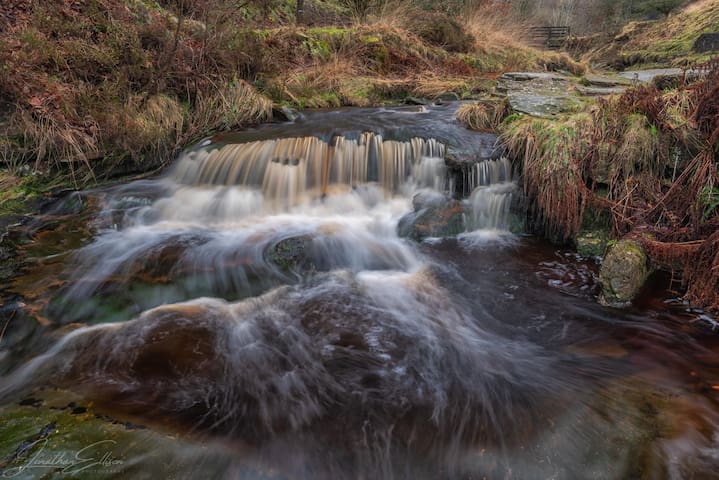
1-2-1 Photography Workshops
If you are just starting out in photography or have some experience but want to step up a level or two then a 1-2-1 workshop is a perfect way to explore and improve your technique and eye for detail, from composition to the final edit.
I run workshops throughout the year, they can be held in our fantastic countryside around Rivington or if you want to explore further afield then there is the option of either the Peak District and Lake District national parks.
Per hour £25 (minimum 2hrs)
Half day 1-2-1 workshops from £125
Full Day 1-2-1 workshop from £200
Discounts for groups, maximum of 3 people.
Full details can be found here ⤵️
https://www.jellisonphoto.co.uk/photography-workshop
Also there is my 2022 Lake District Autumn workshop which is available to book.
This is a group workshop limited to 3 people and consists of a full day of photography in one of the best locations in the UK, with the added bonus of the stunning Autumnal colours.
A day not to be missed 🍂🍂
£160 per person
Lancashire
1-2-1 Photography Workshops
If you are just starting out in photography or have some experience but want to step up a level or two then a 1-2-1 workshop is a perfect way to explore and improve your technique and eye for detail, from composition to the final edit.
I run workshops throughout the year, they can be held in our fantastic countryside around Rivington or if you want to explore further afield then there is the option of either the Peak District and Lake District national parks.
Per hour £25 (minimum 2hrs)
Half day 1-2-1 workshops from £125
Full Day 1-2-1 workshop from £200
Discounts for groups, maximum of 3 people.
Full details can be found here ⤵️
https://www.jellisonphoto.co.uk/photography-workshop
Also there is my 2022 Lake District Autumn workshop which is available to book.
This is a group workshop limited to 3 people and consists of a full day of photography in one of the best locations in the UK, with the added bonus of the stunning Autumnal colours.
A day not to be missed 🍂🍂
£160 per person
Town in central Lancashire, in the United Kingdom. The town proclaims itself to be "Lancashire's Biggest Little Market Town." The town was made famous by repeated references to it by comedian Peter Kay in his stand up shows and his TV programmes "That Peter Kay Thing," "Phoenix Nights" and "Max & Paddy's Road to Nowhere."
The radio station mentioned in the shows, Chorley FM, is fictional and does not exist. However, there have been temporary licenses in the area broadcasting under the name following the programme's success.
Chorley is also famous for its Chorley Cakes, far superior to the nearby Eccles cakes.
You're listening to Chorley FM - where the listener comes first!
8 persone del luogo consigliano

Chorley
Town in central Lancashire, in the United Kingdom. The town proclaims itself to be "Lancashire's Biggest Little Market Town." The town was made famous by repeated references to it by comedian Peter Kay in his stand up shows and his TV programmes "That Peter Kay Thing," "Phoenix Nights" and "Max & Paddy's Road to Nowhere."
The radio station mentioned in the shows, Chorley FM, is fictional and does not exist. However, there have been temporary licenses in the area broadcasting under the name following the programme's success.
Chorley is also famous for its Chorley Cakes, far superior to the nearby Eccles cakes.
You're listening to Chorley FM - where the listener comes first!
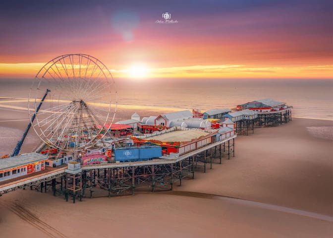
Blackpool is a large town and seaside resort in Lancashire, England. Located on the northwest coast of England, it is the main settlement within the borough also called Blackpool. The town is by the Irish Sea, between the Ribble and Wyre rivers, and is 27 miles north of Liverpool and 40 miles northwest of Manchester. At the 2011 census, the unitary authority of Blackpool had an estimated population of 139,720, while the wider built-up area had a population of 239,409. This makes it the second-largest in Lancashire, as well as the fifth-most populous urban area in northwest England after Manchester, Liverpool, Preston, and Birkenhead.
88 persone del luogo consigliano
Blackpool
Blackpool is a large town and seaside resort in Lancashire, England. Located on the northwest coast of England, it is the main settlement within the borough also called Blackpool. The town is by the Irish Sea, between the Ribble and Wyre rivers, and is 27 miles north of Liverpool and 40 miles northwest of Manchester. At the 2011 census, the unitary authority of Blackpool had an estimated population of 139,720, while the wider built-up area had a population of 239,409. This makes it the second-largest in Lancashire, as well as the fifth-most populous urban area in northwest England after Manchester, Liverpool, Preston, and Birkenhead.
Lytham St Annes is a seaside town in the Borough of Fylde in Lancashire, England. Lytham St Annes is located on the Fylde coast, directly south of Blackpool on the Ribble Estuary. The population at the 2011 census was 42,954. The town is almost contiguous with Blackpool but is separated from it by Blackpool Airport. The town is made up of the four areas of Lytham, Ansdell, Fairhaven and St Annes-on-Sea.
50 persone del luogo consigliano
Lytham St Annes
Lytham St Annes is a seaside town in the Borough of Fylde in Lancashire, England. Lytham St Annes is located on the Fylde coast, directly south of Blackpool on the Ribble Estuary. The population at the 2011 census was 42,954. The town is almost contiguous with Blackpool but is separated from it by Blackpool Airport. The town is made up of the four areas of Lytham, Ansdell, Fairhaven and St Annes-on-Sea.
Walks
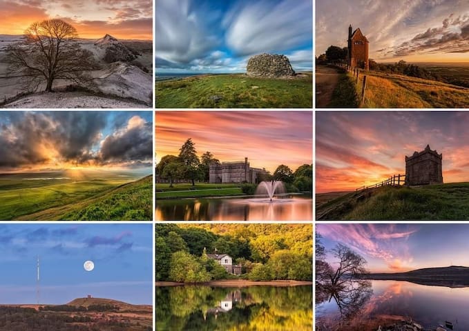
Rivington is a village and civil parish of the Borough of Chorley, Lancashire, England, occupying 2,538 acres. It is about 6 miles southeast of Chorley and about 8+1⁄2 miles northwest of Bolton. Rivington is a rural area consisting primarily of agricultural grazing land, moorland, with hill summits including Rivington Pike and Winter Hill within the West Pennine Moors. The area has a thriving tourist industry centred around reservoirs created to serve Liverpool in the Victorian era and Lever Park created as a public park by William Lever at the turn of the 20th century, with two converted barns, a replica of Liverpool Castle and open countryside. Rivington and its village had a population of 109 at the 2011 Census.
27 persone del luogo consigliano
Rivington Pike Tower
Rivington is a village and civil parish of the Borough of Chorley, Lancashire, England, occupying 2,538 acres. It is about 6 miles southeast of Chorley and about 8+1⁄2 miles northwest of Bolton. Rivington is a rural area consisting primarily of agricultural grazing land, moorland, with hill summits including Rivington Pike and Winter Hill within the West Pennine Moors. The area has a thriving tourist industry centred around reservoirs created to serve Liverpool in the Victorian era and Lever Park created as a public park by William Lever at the turn of the 20th century, with two converted barns, a replica of Liverpool Castle and open countryside. Rivington and its village had a population of 109 at the 2011 Census.
Anglezarke Reservoir is the largest reservoir in the Rivington chain to the west of Anglezarke in Lancashire, England. Anglezarke Reservoir has three embankments: the Charnock Embankment, the longest, is 850 yards long and 31 feet high, the Knowsley Embankment is 240 yards long and 45 feet high and the Heapey Embankment is 280 feet long and 32 feet high. It is fed by the River Yarrow, which has been diverted from its original course which is now covered by the Knowsley Embankment. It served the city of Liverpool before its current status as a supply mainly for Wigan. The original `Rivington Pike Scheme' was undertaken by Thomas Hawksley between 1850 and 1857 for the Liverpool Corporation Waterworks. The scheme was to construct five reservoirs and a water treatment works at the south end of Lower Rivington with a 17-mile pipeline to storage reservoirs at Prescot. Water from two higher level reservoirs, Rake Brook and Lower Roddlesworth, was carried south in `The Goit', a channel connecting them to the reservoirs.
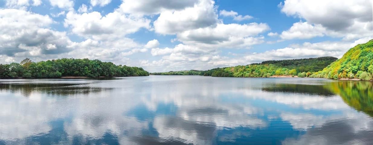
Anglezarke Reservoir
Anglezarke Reservoir is the largest reservoir in the Rivington chain to the west of Anglezarke in Lancashire, England. Anglezarke Reservoir has three embankments: the Charnock Embankment, the longest, is 850 yards long and 31 feet high, the Knowsley Embankment is 240 yards long and 45 feet high and the Heapey Embankment is 280 feet long and 32 feet high. It is fed by the River Yarrow, which has been diverted from its original course which is now covered by the Knowsley Embankment. It served the city of Liverpool before its current status as a supply mainly for Wigan. The original `Rivington Pike Scheme' was undertaken by Thomas Hawksley between 1850 and 1857 for the Liverpool Corporation Waterworks. The scheme was to construct five reservoirs and a water treatment works at the south end of Lower Rivington with a 17-mile pipeline to storage reservoirs at Prescot. Water from two higher level reservoirs, Rake Brook and Lower Roddlesworth, was carried south in `The Goit', a channel connecting them to the reservoirs.
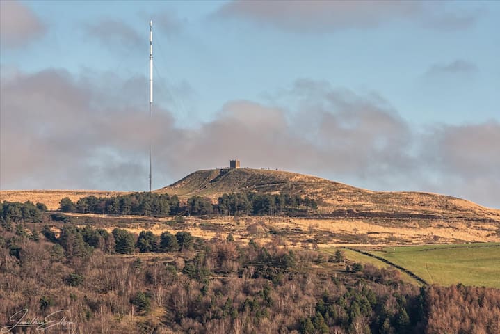
Winter Hill is a hill on the border of the boroughs of Chorley, Blackburn with Darwen and Bolton, in the historic county of Lancashire in North West England. It is located on Rivington Moor, Chorley and is 1,496 feet high. Part of the West Pennine Moors, it is a popular walking area, and has been the site of mining activity, aeroplane disasters and murders.
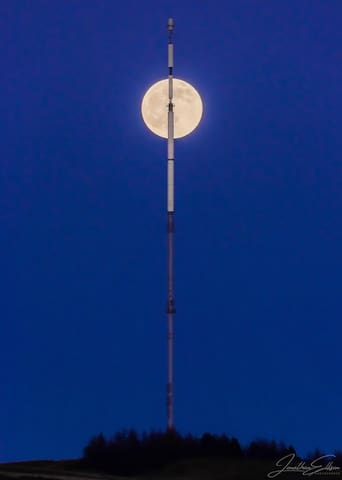
Winter Hill
Winter Hill is a hill on the border of the boroughs of Chorley, Blackburn with Darwen and Bolton, in the historic county of Lancashire in North West England. It is located on Rivington Moor, Chorley and is 1,496 feet high. Part of the West Pennine Moors, it is a popular walking area, and has been the site of mining activity, aeroplane disasters and murders.
Anglezarke is a sparsely populated civil parish in the Borough of Chorley in Lancashire, England. It is dominated by reservoirs that were built to supply water to Liverpool, and a large expanse of moorland with evidence of Bronze Age settlements. Popular with walkers and tourists, it lies in the West Pennine Moors in Lancashire, sandwiched between the moors of Withnell and Rivington, and is close to the towns of Chorley, Horwich and Darwen. At the 2001 census it had a population of 23. At the 2011 Census the population is included within Heapey civil parish.
Anglezarke
Anglezarke is a sparsely populated civil parish in the Borough of Chorley in Lancashire, England. It is dominated by reservoirs that were built to supply water to Liverpool, and a large expanse of moorland with evidence of Bronze Age settlements. Popular with walkers and tourists, it lies in the West Pennine Moors in Lancashire, sandwiched between the moors of Withnell and Rivington, and is close to the towns of Chorley, Horwich and Darwen. At the 2001 census it had a population of 23. At the 2011 Census the population is included within Heapey civil parish.