
Cochrane Guidebook
Food scene
While taking a walk through the heart of Cochrane stop in for an Ice Cream treat, you won't be disappointed!
59 persone del luogo consigliano
MacKay's Ice Cream
220 1 St WWhile taking a walk through the heart of Cochrane stop in for an Ice Cream treat, you won't be disappointed!
Whether you're looking for a nice bowl of soup, a sandwich, coffee, or some of the best desserts you've ever had Guy's has got you covered!
18 persone del luogo consigliano
Guy's Cafe & Bakery
201 Grande BlvdWhether you're looking for a nice bowl of soup, a sandwich, coffee, or some of the best desserts you've ever had Guy's has got you covered!
Family fun
Enjoy some family fun at Spray Lakes sports centre where you can use their public pool that includes water slides, a lazy river, and a wave pool!
21 persone del luogo consigliano
Spray Lake Sawmills Family Sports Centre
800 Griffin Rd EEnjoy some family fun at Spray Lakes sports centre where you can use their public pool that includes water slides, a lazy river, and a wave pool!
Sightseeing
Whether you've brought your fat bike, road bike, or just your hiking boots Glenbow Ranch is the perfect spot to get out and enjoy the beautiful views of the river valley and the surrounding Rocky Mountains.
29 persone del luogo consigliano
Glenbow Ranch Provincial Park
255001 Glenbow RoadWhether you've brought your fat bike, road bike, or just your hiking boots Glenbow Ranch is the perfect spot to get out and enjoy the beautiful views of the river valley and the surrounding Rocky Mountains.
One of a kind provincial park with springs and waterfalls. Short walk, easily accessible to families with small children.
41 persone del luogo consigliano
Big Hill Springs Provincial Park
Big Hill Springs RoadOne of a kind provincial park with springs and waterfalls. Short walk, easily accessible to families with small children.
Day trip ideas
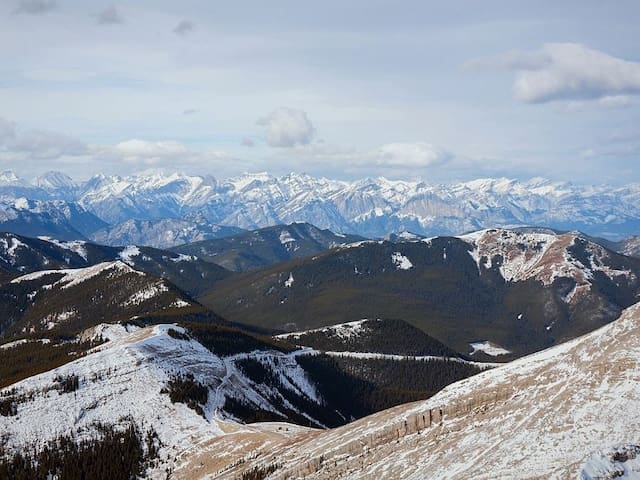
Want to surround yourself with the iconic Rocky Mountains? A quick day trip into Canmore is all you need to experience world class hiking, biking and so much more. With endless hikes to explore, the legacy biking trail, and endless shops to browse, Canmore is the perfect place to explore! Just a 50 minute drive from Cochrane.
307 persone del luogo consigliano
Canmore
Want to surround yourself with the iconic Rocky Mountains? A quick day trip into Canmore is all you need to experience world class hiking, biking and so much more. With endless hikes to explore, the legacy biking trail, and endless shops to browse, Canmore is the perfect place to explore! Just a 50 minute drive from Cochrane.
Get off the beaten path and into the most amazing sightseeing around. Hiking, biking, canoeing and more! Just a short 45 minute drive from our door.
116 persone del luogo consigliano
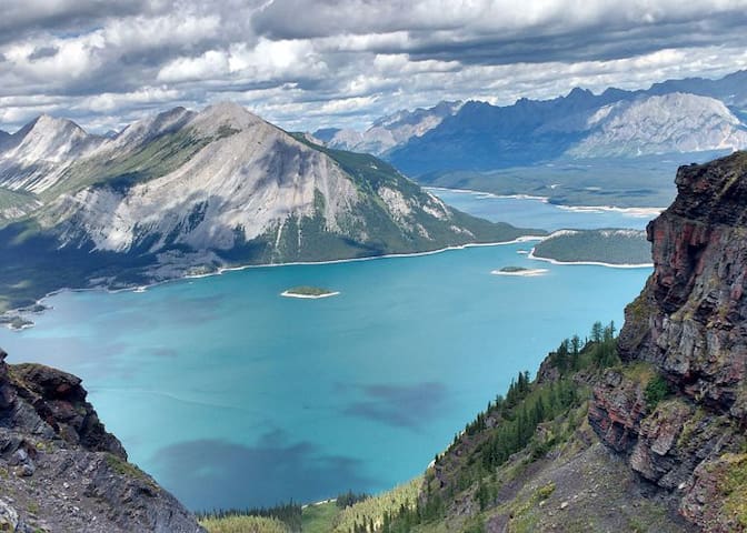
Kananaskis
Get off the beaten path and into the most amazing sightseeing around. Hiking, biking, canoeing and more! Just a short 45 minute drive from our door.
Just an hour drive and you'll be in the iconic Banff National Park. Surround yourself with spectacular view of the mountains, tour through the shops, enjoy some food, whatever it is you're into you're sure to enjoy your time in Banff!
614 persone del luogo consigliano
Banff
Just an hour drive and you'll be in the iconic Banff National Park. Surround yourself with spectacular view of the mountains, tour through the shops, enjoy some food, whatever it is you're into you're sure to enjoy your time in Banff!
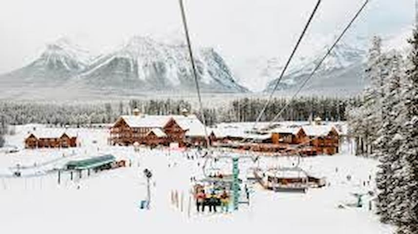
Winter fun
World class skiing and snowboarding is right at your fingertips at Sunshine Village!
142 persone del luogo consigliano
Sunshine Village
World class skiing and snowboarding is right at your fingertips at Sunshine Village!
A great place for beginners to practice their skills while still being in the mountains!
70 persone del luogo consigliano
Area sciistica di Nakiska
2 Mt Allan DrA great place for beginners to practice their skills while still being in the mountains!
Lake Louise Ski Resort
Another epic mountain to explore with incredible runs an amazing views.
The perfect place to try out cross country skiing and many more winter activities!
163 persone del luogo consigliano
Canmore Nordic Centre station
The perfect place to try out cross country skiing and many more winter activities!
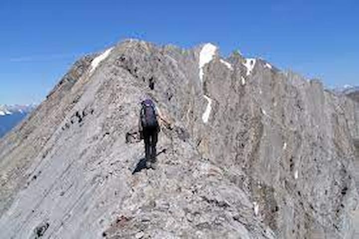
Hikes
Level: Difficult
Beautiful scramble between the 3 peaks of Mount Baldy! Solid rock most of the time with a lot of hands on scrambling if you want. You'll have no choice on the West summit block for sure, but North offers different alternatives.Starting from North summit, path is quite obvious. You have some flags at the beginning and you want to stick on its ridge as most as you can. When you're over the tree line almost, you can scramble up the ridge if you want. There's a place where you down climb with exposure though. If you can't make it, loose elevation and get back to the trail along the crest. Right after this point, there's a bump people take on its right officially. I climbed up that bump and it was not bad at all.Once going from North to South summit, you'll arrive at a cliff after 200-300 metres. You have 2 choices then: Either climb down a wall with good foothold or going back a bit and go down in a little drop right beside the cliff. First option seems to be much better, but we took the second one this time. It was ok, but exposed. It's just a walk after that to the second peak.South to West is a bit more challenging if you don't like hands on scrambling. It's almost straight up with the path going a bit on the right side of the summit block. This is a superb scrambling with solid rock again, but some exposure and technical difficulty. If you have a bit of experience or climbing background (I don't...!), it will not be a problem.Go down West the same way and you'll see a path down closer to the South peak. Nice and easy trail down this gully with a well defined trail.
Directions:
From Calgary, take Highway 1 to Banff up to the Highway 40, where the Casino is located. Once past the casino entrance, it's about 12 km, where you can park at the trailhead on the left side of the road or a few more metres on your right where it looks more like of a parking lot. It's a very busy place.
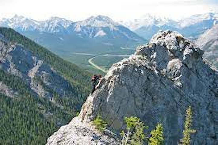
Mount Baldy
Level: Difficult
Beautiful scramble between the 3 peaks of Mount Baldy! Solid rock most of the time with a lot of hands on scrambling if you want. You'll have no choice on the West summit block for sure, but North offers different alternatives.Starting from North summit, path is quite obvious. You have some flags at the beginning and you want to stick on its ridge as most as you can. When you're over the tree line almost, you can scramble up the ridge if you want. There's a place where you down climb with exposure though. If you can't make it, loose elevation and get back to the trail along the crest. Right after this point, there's a bump people take on its right officially. I climbed up that bump and it was not bad at all.Once going from North to South summit, you'll arrive at a cliff after 200-300 metres. You have 2 choices then: Either climb down a wall with good foothold or going back a bit and go down in a little drop right beside the cliff. First option seems to be much better, but we took the second one this time. It was ok, but exposed. It's just a walk after that to the second peak.South to West is a bit more challenging if you don't like hands on scrambling. It's almost straight up with the path going a bit on the right side of the summit block. This is a superb scrambling with solid rock again, but some exposure and technical difficulty. If you have a bit of experience or climbing background (I don't...!), it will not be a problem.Go down West the same way and you'll see a path down closer to the South peak. Nice and easy trail down this gully with a well defined trail.
Directions:
From Calgary, take Highway 1 to Banff up to the Highway 40, where the Casino is located. Once past the casino entrance, it's about 12 km, where you can park at the trailhead on the left side of the road or a few more metres on your right where it looks more like of a parking lot. It's a very busy place.
Level: Difficult
NTS Map: 82O03Elevation Gain: 1200mMount Lady MacDonald is one of those hikes / scrambles that get you addicted to hiking. I've climbed the mountain twice now, and all the hard work of getting to the summit is worth it when you see the amazing views from up there.Be prepared for a fairly long day, however I've seen people in great shape run up and down the mountain in a matter of 3hrs or so. The average hiker would take about 6-7hrs to complete this hike allowing for some rest stops at the helicopter landing pad, and then at the summit. Take lots of water as there is quite a bit of exposure and the sun can really heat you up.
The elevation gain to the summit is 1200m.It would be good to check the Kananaskis trail reports for any bear closures as this is a wildlife corridor and there are some permanent closures in the area, and often there are temporary closures. In the fall of 2005 a lady was killed by a grizzly on the Benchlands trails. Don't let this deter you, but be smart, and go with some friends! The trails are very popular and well used by hikers and mountain bikers.From the Cougar Creek parking area, stay on the West side of the creek and follow the wide trail up into the Benchlands trail system. Soon you'll leave the Benchlands trails behind as you switchback your way up the mountain. It would be good to get a map to help find your way among the many trails at the foot of the mountain.Once you leave the Benchlands behind, you'll be switchbacking through steep terrain in forest, then through a few meadows where on both times I've climbed the mountain I've seen bighorn sheep grazing. After a long hike taking gradual switchbacks and then following a ridge up to the col just above the treeline.Just above the treeline you'll find a large helicopter landing pad, a steel ramp for paragliders, and the remains of a teahouse that was being constructed but is now abandoned.
A gazebo just to the east of the teahouse sits on the edge of a large cliff. The views from here are spectacular. A number of hikers end their hike here as it's already been a hard push to get this far, and the scree slope above can be daunting for non-scramblers.Once taking two steps forward and sliding half a step back to the top, you'll be treated to an amazing knife edge summit. The views across the valley toward the three sisters are great, and you can barely see over Chinaman's peak into the spray lakes valley. More adventurous scramblers will walk the summit ridge, but be warned it's basically a shear drop on one side and a very steep incline on the other. All in all, a breathtaking day, as long as the weather holds out!
Directions:
On the TransCanada highway heading West, take the off-ramp in Canmore north towards the Silvertip resort on Palliser Trail. Follow Palliser Trail road up to the junction and take left to Benchlands Trail road. Just before the bridge on the left along Elk Run Boulevard, you'll reach the Parking by Cougar Creek. Try to get in early as the parking lot fills up with many people using the various trails in the area. Alternate parking could be on the side streets or nearby business area on Benchlands Trail.
15 persone del luogo consigliano
Mount Lady MacDonald
Level: Difficult
NTS Map: 82O03Elevation Gain: 1200mMount Lady MacDonald is one of those hikes / scrambles that get you addicted to hiking. I've climbed the mountain twice now, and all the hard work of getting to the summit is worth it when you see the amazing views from up there.Be prepared for a fairly long day, however I've seen people in great shape run up and down the mountain in a matter of 3hrs or so. The average hiker would take about 6-7hrs to complete this hike allowing for some rest stops at the helicopter landing pad, and then at the summit. Take lots of water as there is quite a bit of exposure and the sun can really heat you up.
The elevation gain to the summit is 1200m.It would be good to check the Kananaskis trail reports for any bear closures as this is a wildlife corridor and there are some permanent closures in the area, and often there are temporary closures. In the fall of 2005 a lady was killed by a grizzly on the Benchlands trails. Don't let this deter you, but be smart, and go with some friends! The trails are very popular and well used by hikers and mountain bikers.From the Cougar Creek parking area, stay on the West side of the creek and follow the wide trail up into the Benchlands trail system. Soon you'll leave the Benchlands trails behind as you switchback your way up the mountain. It would be good to get a map to help find your way among the many trails at the foot of the mountain.Once you leave the Benchlands behind, you'll be switchbacking through steep terrain in forest, then through a few meadows where on both times I've climbed the mountain I've seen bighorn sheep grazing. After a long hike taking gradual switchbacks and then following a ridge up to the col just above the treeline.Just above the treeline you'll find a large helicopter landing pad, a steel ramp for paragliders, and the remains of a teahouse that was being constructed but is now abandoned.
A gazebo just to the east of the teahouse sits on the edge of a large cliff. The views from here are spectacular. A number of hikers end their hike here as it's already been a hard push to get this far, and the scree slope above can be daunting for non-scramblers.Once taking two steps forward and sliding half a step back to the top, you'll be treated to an amazing knife edge summit. The views across the valley toward the three sisters are great, and you can barely see over Chinaman's peak into the spray lakes valley. More adventurous scramblers will walk the summit ridge, but be warned it's basically a shear drop on one side and a very steep incline on the other. All in all, a breathtaking day, as long as the weather holds out!
Directions:
On the TransCanada highway heading West, take the off-ramp in Canmore north towards the Silvertip resort on Palliser Trail. Follow Palliser Trail road up to the junction and take left to Benchlands Trail road. Just before the bridge on the left along Elk Run Boulevard, you'll reach the Parking by Cougar Creek. Try to get in early as the parking lot fills up with many people using the various trails in the area. Alternate parking could be on the side streets or nearby business area on Benchlands Trail.
Level: EasyNTS Map: 082J14Troll Falls trail is part of a network of cross country ski trails which double as hiking trails in the summer. They are located in Kananaskis Country near the base of the Nakiska downhill ski hil which was built for the 1988 Olympic Winter Games. The Troll Falls trail is an easy trail to a nice waterfall. Enjoyable in any season, it follows the ski trails for most of the way, then branches off for the final kilometer. Elevation gain is minor. You can return the same way or keep left at the first fork (returning) and follow the trail along the Kananaskis River.
Directions:
The trailhead is located just off (right) of the Nakiska road about a half mile from highway 40 in Kananaskis. Look for 'Stoney Trailhead' sign.
Troll Falls Trailhead
Level: EasyNTS Map: 082J14Troll Falls trail is part of a network of cross country ski trails which double as hiking trails in the summer. They are located in Kananaskis Country near the base of the Nakiska downhill ski hil which was built for the 1988 Olympic Winter Games. The Troll Falls trail is an easy trail to a nice waterfall. Enjoyable in any season, it follows the ski trails for most of the way, then branches off for the final kilometer. Elevation gain is minor. You can return the same way or keep left at the first fork (returning) and follow the trail along the Kananaskis River.
Directions:
The trailhead is located just off (right) of the Nakiska road about a half mile from highway 40 in Kananaskis. Look for 'Stoney Trailhead' sign.
Level: Difficult
Fire road follows the undulating SE ridge below minor tops barely rising out of the trees at about 4 km and turns to switch backs at about 6.1km climbing to the first summit at 2330m. The Look out, with the main summit are plainly visible.NTS Map: 082J15Elevation Gain: 506 m (1,660 ft).
Directions:
From Hwy 66 0.7km west of Paddy's Flat campground turn north up Moose mountain Road and drive for 7.3 km to parking area and gated trailhead.
6 persone del luogo consigliano
Moose Mountain
Level: Difficult
Fire road follows the undulating SE ridge below minor tops barely rising out of the trees at about 4 km and turns to switch backs at about 6.1km climbing to the first summit at 2330m. The Look out, with the main summit are plainly visible.NTS Map: 082J15Elevation Gain: 506 m (1,660 ft).
Directions:
From Hwy 66 0.7km west of Paddy's Flat campground turn north up Moose mountain Road and drive for 7.3 km to parking area and gated trailhead.
Level: Easy
This is a popular hike and a very popular area for sport climbers. The trail leads to two small turquoise blue lakes. From the parking lot, follow the service road for the first 100 metres, then keep left on the well-defined hiking trail. The first kilometre is a gentle ascent through forest with a delightful assortment of wildflowers in bloom throughout the month of June. Approximately 100 meters into the hike is the first intersection (waypoint #002). At this point you can choose the easy or more difficult route. The easy route appears to be a fire road but by taking this route you miss out on the waterfall and views of Canmore and the Bow Valley.
The more difficult route is not very difficult but as always you have to watch your footing. On the more difficult route there is a series of stairs to make the climb easier. On the way up are great views of Ha Ling Peak and at the top the two lakes. For more adventurous souls, a short scramble above the upper lake takes you to a canyon and a genuine petroglyph on a large boulder. The area around and above the upper lake is also a popular spot for sport climbing and provides lots of entertainment if you like watching spandex-clad climbers practice their moves.
Directions:
The trailhead is located 4.7 km south of Canmore on the Smith-Dorrien-Spray Lakes Road (Highway 742).To get there from the west or far end of Canmore's Main Street (8th St.), follow the signs for the Canmore Nordic Centre which will take you south of town. When you reach the end of the pavement just past the Nordic Centre, turn left at the Grassi Lakes sign. Follow this descending road for 500 metres and you will see the trailhead on your right.
155 persone del luogo consigliano
Laghi Grassi
Level: Easy
This is a popular hike and a very popular area for sport climbers. The trail leads to two small turquoise blue lakes. From the parking lot, follow the service road for the first 100 metres, then keep left on the well-defined hiking trail. The first kilometre is a gentle ascent through forest with a delightful assortment of wildflowers in bloom throughout the month of June. Approximately 100 meters into the hike is the first intersection (waypoint #002). At this point you can choose the easy or more difficult route. The easy route appears to be a fire road but by taking this route you miss out on the waterfall and views of Canmore and the Bow Valley.
The more difficult route is not very difficult but as always you have to watch your footing. On the more difficult route there is a series of stairs to make the climb easier. On the way up are great views of Ha Ling Peak and at the top the two lakes. For more adventurous souls, a short scramble above the upper lake takes you to a canyon and a genuine petroglyph on a large boulder. The area around and above the upper lake is also a popular spot for sport climbing and provides lots of entertainment if you like watching spandex-clad climbers practice their moves.
Directions:
The trailhead is located 4.7 km south of Canmore on the Smith-Dorrien-Spray Lakes Road (Highway 742).To get there from the west or far end of Canmore's Main Street (8th St.), follow the signs for the Canmore Nordic Centre which will take you south of town. When you reach the end of the pavement just past the Nordic Centre, turn left at the Grassi Lakes sign. Follow this descending road for 500 metres and you will see the trailhead on your right.