
Lance’s Guidebook to Southern UT
Food scene
Great food, but it can get busy so call ahead!
24 persone del luogo consigliano
Pig's Ear American Bistro
75 2000 WGreat food, but it can get busy so call ahead!
Decent BBQ, but not super consistent so don't hold me to it. I like the burnt ends sandwich!
72 persone del luogo consigliano
Lonny Boy's BBQ
980 W State StDecent BBQ, but not super consistent so don't hold me to it. I like the burnt ends sandwich!
Excellent pizza, the best sit down pizza in Washington County. Amazing coffee and breakfast food. This is a very busy place, so plan ahead!
228 persone del luogo consigliano
River Rock Roasting Company
394 S State StExcellent pizza, the best sit down pizza in Washington County. Amazing coffee and breakfast food. This is a very busy place, so plan ahead!
Main Street Café
138 Main StBest breakfast in Hurricane!
If you need coffee, Perks has you covered. Less than a mile from the house in the Wendy's parking lot.
9 persone del luogo consigliano
Perks! Espresso & Smoothies
740 W Telegraph StIf you need coffee, Perks has you covered. Less than a mile from the house in the Wendy's parking lot.
If you want an authentic Mexican taqueria, this is the place. This is my favorite Mexican food in town.
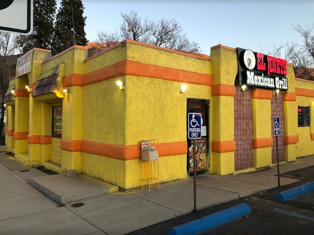
El Jinete
70 East State StreetIf you want an authentic Mexican taqueria, this is the place. This is my favorite Mexican food in town.
This funky little restaurant is one of our favorites in Springdale (Zion).
17 persone del luogo consigliano
Whiptail Grill
445 Zion Park BlvdThis funky little restaurant is one of our favorites in Springdale (Zion).
After a long hike in Zion, nothing will cure your hunger like a massive and delicious burger from Oscar's. One of the most popular food joints in Springdale (Zion), this place can get busy.
110 persone del luogo consigliano
Oscar's Cafe
948 Zion Park BlvdAfter a long hike in Zion, nothing will cure your hunger like a massive and delicious burger from Oscar's. One of the most popular food joints in Springdale (Zion), this place can get busy.
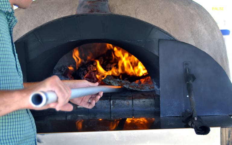
Dixie Pizza Wagon! This place is a little funky home made pizza trailer on the side of State St in Hurricane. Believe it or not, this place just got rated the 5th best pizza place in the entire United States! Not only is it delicious, it is cheap! For 9 bucks get one of the best pizzas in the USA. Be prepared to wait, you may want to call ahead.
713 State St, Hurricane, UT 84737, Stati Uniti
Dixie Pizza Wagon! This place is a little funky home made pizza trailer on the side of State St in Hurricane. Believe it or not, this place just got rated the 5th best pizza place in the entire United States! Not only is it delicious, it is cheap! For 9 bucks get one of the best pizzas in the USA. Be prepared to wait, you may want to call ahead.
Bike Shop
Best bike shop in Southern UT, and it's about 4 minutes away.
21 persone del luogo consigliano
Over the Edge Sports
76 E 100 SBest bike shop in Southern UT, and it's about 4 minutes away.
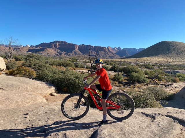
Bike Trails
The JEM trail system is accessible from the house if you're not afraid of pedaling up the hill to get to it. If you'd prefer, you can take the short drive up the hill to get to one of the many parking lots. The JEM trail system has many trails on it. I recommend using Trail Forks to pick out your perfect route. A fantastic 21-ish (or more) mile loop can be made riding directly from the MTBCasita.
6 persone del luogo consigliano
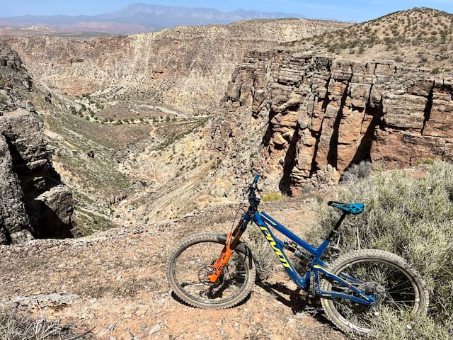
JEM Trail
JEM TrailThe JEM trail system is accessible from the house if you're not afraid of pedaling up the hill to get to it. If you'd prefer, you can take the short drive up the hill to get to one of the many parking lots. The JEM trail system has many trails on it. I recommend using Trail Forks to pick out your perfect route. A fantastic 21-ish (or more) mile loop can be made riding directly from the MTBCasita.
If it's your first time to our area, Gooseberry is a must. Its our most famous trail. It's not for beginners, though. It's a long bumpy road to get to the trailhead. Bring plenty of water, snacks, and be self sufficient. I recommend using Trail Forks to plan the perfect route. There are endless options. My favorite route starting off from the White parking lot and going clockwise on South Rim.
29 persone del luogo consigliano
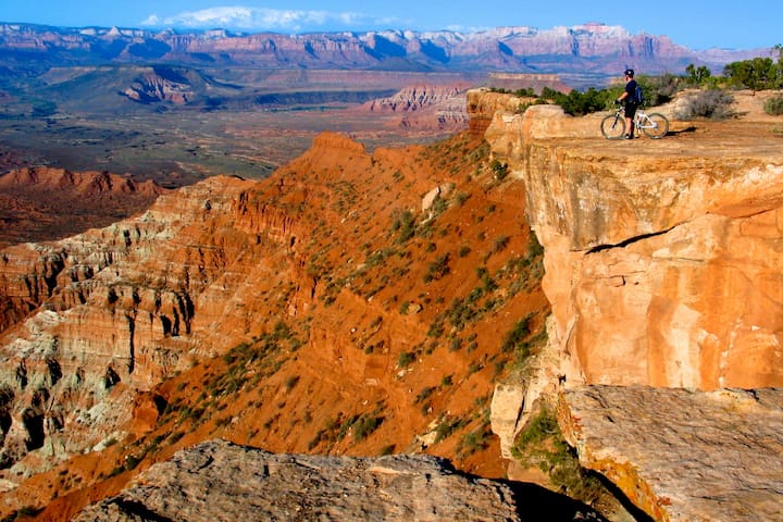
Gooseberry Mesa
If it's your first time to our area, Gooseberry is a must. Its our most famous trail. It's not for beginners, though. It's a long bumpy road to get to the trailhead. Bring plenty of water, snacks, and be self sufficient. I recommend using Trail Forks to plan the perfect route. There are endless options. My favorite route starting off from the White parking lot and going clockwise on South Rim.
A fantastic intermediate 7.5 mile loop (you can go either direction, counter clockwise is easier, clockwise is a little more challenging) with spectacular views of Zion National Park. I highly recommend this trail.
Wire Mesa Trailhead
A fantastic intermediate 7.5 mile loop (you can go either direction, counter clockwise is easier, clockwise is a little more challenging) with spectacular views of Zion National Park. I highly recommend this trail.
This is one of my favorites. It's similar to Gooseberry, but less people. The scenery is insane with views of the backside of Zion National Park. Take lots of water and do the full loop (about 10 miles) and take lots of pictures!
Whole Guacamole Trailhead
This is one of my favorites. It's similar to Gooseberry, but less people. The scenery is insane with views of the backside of Zion National Park. Take lots of water and do the full loop (about 10 miles) and take lots of pictures!
Recreation
There is an amazing lake with boat/SUP/jet ski/off road vehicle rentals about 10 minutes from the house. It's a must visit if you've never been.
Not only is Sand Hollow an amazing destination for the lake, but it's also an off roader's paradise! With thousands of acres of off roading for ATV/UTV/Jeeps/Dirt Bikes, you will be blown away at the scenery, and different types of terrain available. From mild to wild, there is something for all off road abilities at Sand Hollow.
301 persone del luogo consigliano
Parco Statale di Sand Hollow
3351 Sand Hollow RdThere is an amazing lake with boat/SUP/jet ski/off road vehicle rentals about 10 minutes from the house. It's a must visit if you've never been.
Not only is Sand Hollow an amazing destination for the lake, but it's also an off roader's paradise! With thousands of acres of off roading for ATV/UTV/Jeeps/Dirt Bikes, you will be blown away at the scenery, and different types of terrain available. From mild to wild, there is something for all off road abilities at Sand Hollow.
Snow Canyon State Park is a 7,400-acre scenic park quietly tucked amid lava flows and soaring sandstone cliffs in a strikingly colorful and fragile desert environment. Majestic views and the subtle interplay of light, shadow, and color dancing across canyon walls evoke strong emotional responses from visitors.
Located in the 62,000 acre Red Cliffs Desert Reserve, established to protect the federally listed desert tortoise and its habitat, the park offers opportunities for outdoor enthusiasts of all ages. Activities include hiking, nature studies, wildlife viewing, photography, camping, ranger talks, and junior ranger programs. There are more than 38 miles of hiking trails, a three-mile paved walking/biking trail, and over 15 miles of equestrian trails.
342 persone del luogo consigliano
Parco Statale di Snow Canyon
1002 Snow Canyon DrSnow Canyon State Park is a 7,400-acre scenic park quietly tucked amid lava flows and soaring sandstone cliffs in a strikingly colorful and fragile desert environment. Majestic views and the subtle interplay of light, shadow, and color dancing across canyon walls evoke strong emotional responses from visitors.
Located in the 62,000 acre Red Cliffs Desert Reserve, established to protect the federally listed desert tortoise and its habitat, the park offers opportunities for outdoor enthusiasts of all ages. Activities include hiking, nature studies, wildlife viewing, photography, camping, ranger talks, and junior ranger programs. There are more than 38 miles of hiking trails, a three-mile paved walking/biking trail, and over 15 miles of equestrian trails.
Boasting some of the warmest waters in the state and a mild winter climate, Quail Creek lures boaters and anglers year-round. Camp. Hike. Explore.
130 persone del luogo consigliano
Parco Statale di Quail Creek
472 5300 WestBoasting some of the warmest waters in the state and a mild winter climate, Quail Creek lures boaters and anglers year-round. Camp. Hike. Explore.
Go check out the waterfalls! With all of the rain we've had recently in Southern Utah, the waterfalls are a sight to be seen. Just be careful!
29 persone del luogo consigliano
Parco Statale di Gunlock
Gunlock RoadGo check out the waterfalls! With all of the rain we've had recently in Southern Utah, the waterfalls are a sight to be seen. Just be careful!
Zion Hiking
Family friendly hike, outside of Angels Landing, it doesn't get much more classic than the Emerald Pools of Zion National Park. Located directly across from the Historic Zion Lodge, which means easy access and plenty of traffic. The trail follows a small stream that collects in a series of "pools."
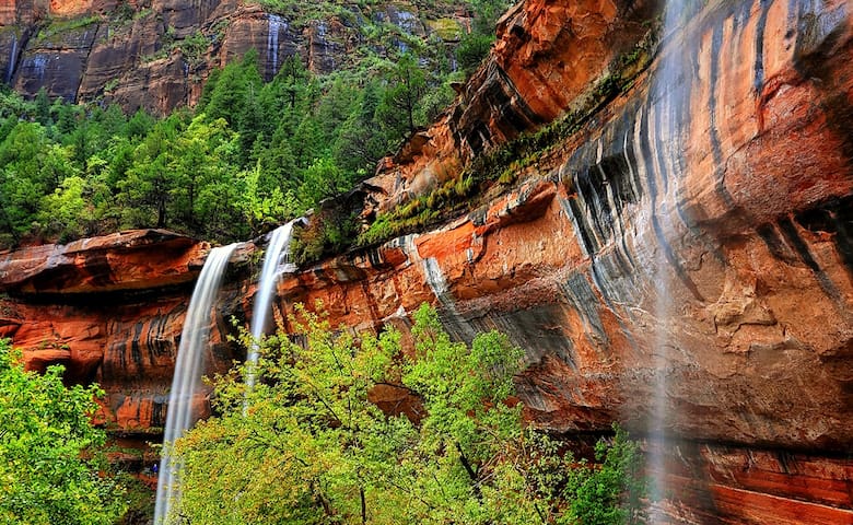
Emerald Pools Trail
Emerald Pools TrailFamily friendly hike, outside of Angels Landing, it doesn't get much more classic than the Emerald Pools of Zion National Park. Located directly across from the Historic Zion Lodge, which means easy access and plenty of traffic. The trail follows a small stream that collects in a series of "pools."
Angels Landing in Zion National Park is one of the most spectacular day hikes in the world. The trail to its lofty summit was hewn out of its steep, rock-solid spine in 1926 and it continues to thrill hikers to this day. The hike climbs up roughly 1,500 vertical feet along the narrow fin of stone that reaches a top elevation of 5,790 feet. A chain railing adds an element of safety, but if exposed heights make you weak in the knees, it will take a double-dose of courage to make the summit. This trail requires getting a permit in advance.
30 persone del luogo consigliano
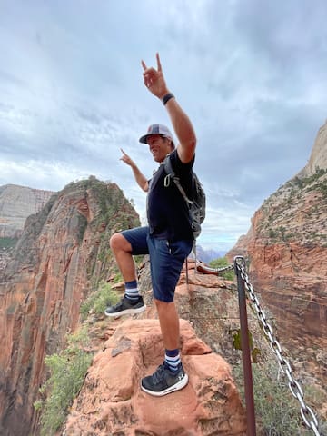
Cima di Angels Landing
Angels Landing TrailAngels Landing in Zion National Park is one of the most spectacular day hikes in the world. The trail to its lofty summit was hewn out of its steep, rock-solid spine in 1926 and it continues to thrill hikers to this day. The hike climbs up roughly 1,500 vertical feet along the narrow fin of stone that reaches a top elevation of 5,790 feet. A chain railing adds an element of safety, but if exposed heights make you weak in the knees, it will take a double-dose of courage to make the summit. This trail requires getting a permit in advance.
This hike follows the North Fork of the Virgin River up the lower half of the spectacular Narrows of Zion Canyon to Orderville Canyon or Big Springs (although you have the option of turning around earlier). This is the most famous backcountry area of Zion, and for good reason: stunning thousand-foot walls of Navajo sandstone rise on both sides, and centuries of erosion have sculpted the rock into surreal fluted and whorled forms. While a hike (from the bottom up) or canyoneering adventure (with a permit or guide from the top down) through the Narrows in Zion National Park is one you will never forget, hiking in a river comes with inherent risks. Check conditions locally.
Safety is paramount. Travelers should expect nearly constant wading on this hike. Be ready for slippery cobbles in water that may be waist deep and quite cold. Overnight camping is not allowed in this section of the canyon, but no special permit is required to undertake the trek. You will need to check the river flow rates, however, because the National Park Service closes the canyon to hikers coming up from the bottom when river flows surpass 150 cubic feet per second. Check for flash flood warnings at park headquarters before starting out to make sure the trail is open and safe. There is little in the way of escape terrain should a cloudburst high in the headwaters send a wall of water down the canyon.
The hike begins on a paved walkway that departs from the Temple of Sinawava parking area. At the end of the paved path, the river hike begins. Follow the trails along riverside gravel bars and cross the river at shallow spots when sheer walls block progress on land. A trickle of cool water cascades down the east wall of the canyon, marking the elevated mouth of Mystery Canyon. The Narrows begin just beyond this point, as immense walls constrict around the watercourse. The wading is virtually constant from this point onward, but the longer you stick with it, the greater the rewards.
32 persone del luogo consigliano
The Narrows
This hike follows the North Fork of the Virgin River up the lower half of the spectacular Narrows of Zion Canyon to Orderville Canyon or Big Springs (although you have the option of turning around earlier). This is the most famous backcountry area of Zion, and for good reason: stunning thousand-foot walls of Navajo sandstone rise on both sides, and centuries of erosion have sculpted the rock into surreal fluted and whorled forms. While a hike (from the bottom up) or canyoneering adventure (with a permit or guide from the top down) through the Narrows in Zion National Park is one you will never forget, hiking in a river comes with inherent risks. Check conditions locally.
Safety is paramount. Travelers should expect nearly constant wading on this hike. Be ready for slippery cobbles in water that may be waist deep and quite cold. Overnight camping is not allowed in this section of the canyon, but no special permit is required to undertake the trek. You will need to check the river flow rates, however, because the National Park Service closes the canyon to hikers coming up from the bottom when river flows surpass 150 cubic feet per second. Check for flash flood warnings at park headquarters before starting out to make sure the trail is open and safe. There is little in the way of escape terrain should a cloudburst high in the headwaters send a wall of water down the canyon.
The hike begins on a paved walkway that departs from the Temple of Sinawava parking area. At the end of the paved path, the river hike begins. Follow the trails along riverside gravel bars and cross the river at shallow spots when sheer walls block progress on land. A trickle of cool water cascades down the east wall of the canyon, marking the elevated mouth of Mystery Canyon. The Narrows begin just beyond this point, as immense walls constrict around the watercourse. The wading is virtually constant from this point onward, but the longer you stick with it, the greater the rewards.
The Zion Canyon Overlook Trail is located just east of the famous Zion-Mt. Carmel Tunnel. The trail is just half a mile long, but it delivers some of the most spectacular views in the park. It’s easy to reach and relatively flat, making it a popular spot for many hikers. But don’t let the fear of crowds deter you from enjoying this path that travels above the Great Arch and features one of the signature views of Zion Canyon.
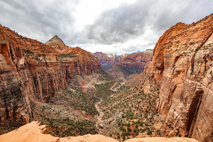
Zion Overlook
Cedar CanyonThe Zion Canyon Overlook Trail is located just east of the famous Zion-Mt. Carmel Tunnel. The trail is just half a mile long, but it delivers some of the most spectacular views in the park. It’s easy to reach and relatively flat, making it a popular spot for many hikers. But don’t let the fear of crowds deter you from enjoying this path that travels above the Great Arch and features one of the signature views of Zion Canyon.
The Watchman is a 2.7 mile out-and-back hike that passes overhanging cliffs and stratified rock layers as it leads into the foothills below The Watchman and Bridge Mountain. The trail begins from the shuttle stop and follows the bank of the Virgin River upstream.
The Watchman
The Watchman is a 2.7 mile out-and-back hike that passes overhanging cliffs and stratified rock layers as it leads into the foothills below The Watchman and Bridge Mountain. The trail begins from the shuttle stop and follows the bank of the Virgin River upstream.
Consigli per viaggiatori
Prenota prima di andarci
Zion Jeep Tours - www.zionjeeptours.com
Zion National Park contains some of Earth’s most spectacular scenery, yet the vast majority of its 5 million annual visitors will never experience Zion beyond a few feet off the pavement. Those who do know that nature’s best kept secrets are reserved for those who venture beyond the well-worn trail.
Our tours makes it easy to experience many of southern Utah’s hidden treasures. We take the road less traveled to show you places that most visitors see only in photographs, including stunning panoramas and breathtaking overlooks that have remained unchanged for a million years. Call 435-668-3756