
Parks and Trails
Sightseeing
This is a 7 km paved multi-use recreational trail that stretches from Lakeview Park to the Oshawa Valley Botanical Garden. Surrounded by lush vegetation the recreational trail meanders along the Oshawa Creek. Along the recreational trail there are connections to other recreational trails including the Michael Starr Trail, Harmony Creek Trail, and other attractions including Oshawa Valley Botanical Garden and downtown Oshawa. Portions of the recreational trail travel close to the creek and has steep slopes, sharp turns and unprotected edges. Caution should be used when accessing and maneuvering the recreational trail.
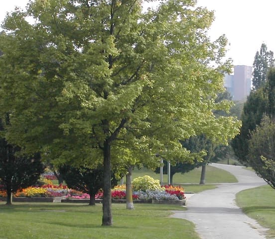
Joseph Kolodzie Oshawa Creek Bike Path
Joseph Kolodzie Oshawa Creek Bike PathThis is a 7 km paved multi-use recreational trail that stretches from Lakeview Park to the Oshawa Valley Botanical Garden. Surrounded by lush vegetation the recreational trail meanders along the Oshawa Creek. Along the recreational trail there are connections to other recreational trails including the Michael Starr Trail, Harmony Creek Trail, and other attractions including Oshawa Valley Botanical Garden and downtown Oshawa. Portions of the recreational trail travel close to the creek and has steep slopes, sharp turns and unprotected edges. Caution should be used when accessing and maneuvering the recreational trail.
This is a 5 km multi-use paved recreational trail that follows a former CN spur line into downtown Oshawa. Users can connect with other recreational trails including the Joseph Kolodzie Oshawa Creek Bike Path and the Harmony Creek Trail through on road connections. Relatively flat in nature, the recreational trail has many road crossings. Caution should be used when approaching and crossing intersections.
Michael Starr Trail
Michael Starr TrailThis is a 5 km multi-use paved recreational trail that follows a former CN spur line into downtown Oshawa. Users can connect with other recreational trails including the Joseph Kolodzie Oshawa Creek Bike Path and the Harmony Creek Trail through on road connections. Relatively flat in nature, the recreational trail has many road crossings. Caution should be used when approaching and crossing intersections.
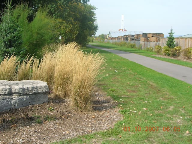
This is a 4 km paved multi-use recreational trail that travels along the Harmony Creek. It is surrounded by nature and lush vegetation with access to Donevan Recreation Complex and a number of parks including Farewell Park and Eastbourne Park. Users can also connect on road to other recreational trails such as the Joseph Kolodzie Oshawa Creek Bike Path and the Michael Starr Trail. The recreational trail has a number of steep slopes and edges that are close to the creek. Caution is advised when accessing and using the recreational trail.
April 1 to October 31 - 6:00 a.m. to 10:00 p.m. November 1 to March 31 - 6:00 a.m. to 6:00 p.m.
Harmony Creek Trail
Harmony Creek TrailThis is a 4 km paved multi-use recreational trail that travels along the Harmony Creek. It is surrounded by nature and lush vegetation with access to Donevan Recreation Complex and a number of parks including Farewell Park and Eastbourne Park. Users can also connect on road to other recreational trails such as the Joseph Kolodzie Oshawa Creek Bike Path and the Michael Starr Trail. The recreational trail has a number of steep slopes and edges that are close to the creek. Caution is advised when accessing and using the recreational trail.
April 1 to October 31 - 6:00 a.m. to 10:00 p.m. November 1 to March 31 - 6:00 a.m. to 6:00 p.m.
Nice Walking Trails -- 915 Grandview St. N.
The park is approximately 28 hectares containing a mix of habitats including hardwood forests, coniferous plantations, open fields, meadows, and wetlands. The Harmony Creek flows through the park. The historic Lake Iroquois Shoreline runs along the north edge and is a unique geological feature. With its nature trails the Harmony Valley Park is enjoyed by walkers, hikers, runners, and nature enthusiasts. The park also contains a popular off-leash area run by volunteers of the Oshawa Durham Area Walkers Group who care for and maintain the off-leash area. The use of the park requires sensitivity in order to balance the preservation of the natural surroundings with the diverse recreational uses. There are a number of recreational nature trails throughout the park. Users are asked to stay on the designated recreational trails and respect all users.
Hours: April 1 to October 31 - 6:00 a.m. to 10:00 p.m. November 1 to March 31 - 6:00 a.m. to 6:00 p.m.
7 persone del luogo consigliano
Harmony Valley Conservation Area & Off-Leash Dog Park
915 Grandview St NNice Walking Trails -- 915 Grandview St. N.
The park is approximately 28 hectares containing a mix of habitats including hardwood forests, coniferous plantations, open fields, meadows, and wetlands. The Harmony Creek flows through the park. The historic Lake Iroquois Shoreline runs along the north edge and is a unique geological feature. With its nature trails the Harmony Valley Park is enjoyed by walkers, hikers, runners, and nature enthusiasts. The park also contains a popular off-leash area run by volunteers of the Oshawa Durham Area Walkers Group who care for and maintain the off-leash area. The use of the park requires sensitivity in order to balance the preservation of the natural surroundings with the diverse recreational uses. There are a number of recreational nature trails throughout the park. Users are asked to stay on the designated recreational trails and respect all users.
Hours: April 1 to October 31 - 6:00 a.m. to 10:00 p.m. November 1 to March 31 - 6:00 a.m. to 6:00 p.m.
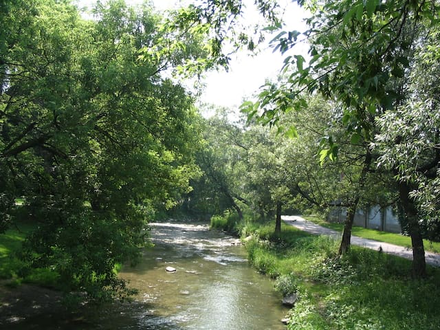
Extends from Adelaide Avenue to Gibb Street along the Oshawa Creek. Close to walk Dowtown and also reach another close by trail.
The Oshawa Valley Botanical Garden (OVBG) is a network of parks and gardens along the Oshawa Creek from Adelaide Avenue to Gibb Street. It is linked by the natural area of the Oshawa Creek and the Joseph Kolodzie Oshawa Creek Bike Path. Visitors can explore the many features and attractions that make up the network.
With stunning gardens, architectural features, serene water features and winding pathways, the scenery of the Oshawa Valley Botanical Gardens is second to none. The gardens are stunning throughout the summer, with each week revealing something new in the gardens and natural surroundings. The OVBG is a “master planned” garden that, when fully completed, will include parks, trails and 11 planned garden districts for all to enjoy.
Hours: April 1 to October 31 - 6:00 a.m. to 10:00 p.m. November 1 to March 31 - 6 a.m. to 6 p.m.
14 persone del luogo consigliano
Giardino Botanico della Valle di Oshawa
155 Arena StExtends from Adelaide Avenue to Gibb Street along the Oshawa Creek. Close to walk Dowtown and also reach another close by trail.
The Oshawa Valley Botanical Garden (OVBG) is a network of parks and gardens along the Oshawa Creek from Adelaide Avenue to Gibb Street. It is linked by the natural area of the Oshawa Creek and the Joseph Kolodzie Oshawa Creek Bike Path. Visitors can explore the many features and attractions that make up the network.
With stunning gardens, architectural features, serene water features and winding pathways, the scenery of the Oshawa Valley Botanical Gardens is second to none. The gardens are stunning throughout the summer, with each week revealing something new in the gardens and natural surroundings. The OVBG is a “master planned” garden that, when fully completed, will include parks, trails and 11 planned garden districts for all to enjoy.
Hours: April 1 to October 31 - 6:00 a.m. to 10:00 p.m. November 1 to March 31 - 6 a.m. to 6 p.m.
Located just west of Orono Village within the Wilmot Creek watershed, the Lands offer significant aquatic natural resources. They are a haven for frongs, salmon, rainbow and brown trout. The Lands feature abandoned nursery production beds, natural forested areas, abandoned seed orchards and open fields, along with the remnants of man-made structures.
The Orono Crown Lands Trust (OCLT) is an incorporated, charitable, non-profit volunteer group who manages the Orono Crown Lands in partnership with the Ministry of Natural Resources (MNR). The Orono Crown Lands are situated just west of the village of Orono and consist of 633 acres. It can be accessed from both Taunton Road and from Ochonski Road and lies within the Wilmot Creek watershed which offers significant aquatic natural resources, including brown trout. The Orono Crown Lands feature abandoned nursery production beds, natural forested areas, abandoned seed orchards and open fields, along with the remnants of man-made structures and new hiking trails.
The Orono Crown Lands were originally purchased by the Province as a tree nursery, to be operated by the MNR. In addition to growing and shipping seedlings, the Ministry used the lands for forest research projects. It ceased to operate it as a farm in 1996. In 2001 the MNR partnered with the OCLT to manage and maintain the property. The OCLT works to ensure the property continues to be open to the public and has improved parking facilities, trails and access roads.
The seven trails totaling 13 km wind across 633 acres of forest land and meadows and often follow Wilmot Creek and Orono Creek. They include the Purple Trail (1 km), Red Loop (1.5 km), Orange Loop (2.3 km), Blue Loop (2.5 km), Green Trail (1.8 km), Linton Red Trail (1.7 km) and the Linton Orange Trail (2.3 km).
For more information please visit the Orono Crown Lands Trust website.
6 persone del luogo consigliano
Orono Crown Lands
Ochonski RoadLocated just west of Orono Village within the Wilmot Creek watershed, the Lands offer significant aquatic natural resources. They are a haven for frongs, salmon, rainbow and brown trout. The Lands feature abandoned nursery production beds, natural forested areas, abandoned seed orchards and open fields, along with the remnants of man-made structures.
The Orono Crown Lands Trust (OCLT) is an incorporated, charitable, non-profit volunteer group who manages the Orono Crown Lands in partnership with the Ministry of Natural Resources (MNR). The Orono Crown Lands are situated just west of the village of Orono and consist of 633 acres. It can be accessed from both Taunton Road and from Ochonski Road and lies within the Wilmot Creek watershed which offers significant aquatic natural resources, including brown trout. The Orono Crown Lands feature abandoned nursery production beds, natural forested areas, abandoned seed orchards and open fields, along with the remnants of man-made structures and new hiking trails.
The Orono Crown Lands were originally purchased by the Province as a tree nursery, to be operated by the MNR. In addition to growing and shipping seedlings, the Ministry used the lands for forest research projects. It ceased to operate it as a farm in 1996. In 2001 the MNR partnered with the OCLT to manage and maintain the property. The OCLT works to ensure the property continues to be open to the public and has improved parking facilities, trails and access roads.
The seven trails totaling 13 km wind across 633 acres of forest land and meadows and often follow Wilmot Creek and Orono Creek. They include the Purple Trail (1 km), Red Loop (1.5 km), Orange Loop (2.3 km), Blue Loop (2.5 km), Green Trail (1.8 km), Linton Red Trail (1.7 km) and the Linton Orange Trail (2.3 km).
For more information please visit the Orono Crown Lands Trust website.
Located north of Bowmanville, the Stephen's Gulch Conservation Area borders a significant portion of the Soper Creek.
The Conservation Area protects a large area of deciduous forest and coniferous forest/swamp that help maintain both water quantity (through seeps and springs) and water temperature along this section the Soper Creek.
Stephen's Gulch Conservation Area also includes a portion of the provincially significant Soper Valley Area of Natural and Scientific Interest (ANSI).
Exit 401 at Liberty Street in Bowmanville (432), take Liberty Street North to Concession Road 4, turn right on Concession Road 4, turn left onto Bethesda Rd, take 1st right onto Stephens Mill Rd.
Only In Clarington
Walk, hike, cycle, run or take your dog. This is a great forested trail to experience nice summer shade to keep cool. An area to study plants and learn about wildlife like frogs, slugs and ferns. It borders on Soper Creek and includes part of the Soper Creek Valley. All dogs must be leashed and parking is available.
Stephen's Gulch Conservation Area
367 Stephens Mill RdLocated north of Bowmanville, the Stephen's Gulch Conservation Area borders a significant portion of the Soper Creek.
The Conservation Area protects a large area of deciduous forest and coniferous forest/swamp that help maintain both water quantity (through seeps and springs) and water temperature along this section the Soper Creek.
Stephen's Gulch Conservation Area also includes a portion of the provincially significant Soper Valley Area of Natural and Scientific Interest (ANSI).
Exit 401 at Liberty Street in Bowmanville (432), take Liberty Street North to Concession Road 4, turn right on Concession Road 4, turn left onto Bethesda Rd, take 1st right onto Stephens Mill Rd.
Only In Clarington
Walk, hike, cycle, run or take your dog. This is a great forested trail to experience nice summer shade to keep cool. An area to study plants and learn about wildlife like frogs, slugs and ferns. It borders on Soper Creek and includes part of the Soper Creek Valley. All dogs must be leashed and parking is available.
Darlington Provincial Park is a part of the Ontario Provincial Parks system. It is located just south of Highway 401 near the town of Courtice, between the cities of Bowmanville and Oshawa.
Address: 1600 Darlington Park Rd., Bowmanville
What You'll Like :
Family camping experience close to home, Great day-use and Picnic Facilities, Group Picnic and Camping Opportunities, Nature trails, a long Sandy Beach on Lake Ontario, Interpretive Programs and Special Events.
20 persone del luogo consigliano
Parco Provinciale Darlington
1600 Darlington Park RdDarlington Provincial Park is a part of the Ontario Provincial Parks system. It is located just south of Highway 401 near the town of Courtice, between the cities of Bowmanville and Oshawa.
Address: 1600 Darlington Park Rd., Bowmanville
What You'll Like :
Family camping experience close to home, Great day-use and Picnic Facilities, Group Picnic and Camping Opportunities, Nature trails, a long Sandy Beach on Lake Ontario, Interpretive Programs and Special Events.
Natural area with around 400 kinds of plants, lots of wildlife, walking trails & viewing platforms.
Address: 1908 Colonel Sam Dr, Oshawa, ON L1H 8W8
Phone: (905) 644-1689
7 persone del luogo consigliano
McLaughlin Bay Wildlife Reserve
1908 Colonel Sam DrNatural area with around 400 kinds of plants, lots of wildlife, walking trails & viewing platforms.
Address: 1908 Colonel Sam Dr, Oshawa, ON L1H 8W8
Phone: (905) 644-1689
Heber Down Conservation Area is located in Whitby, Ontario and is owned and operated by Central Lake Ontario Conservation Authority. It is located within the Lynde Creek drainage basin; it is a part of the provincially significant Heber Down Wetland Complex.
Address: 5000 Cochrane St, Whitby, ON L1P 2A3
Hours:
Saturday 7:30a.m.–8p.m.
Sunday 7:30a.m.–8p.m.
Monday 7:30a.m.–8p.m.
Tuesday 7:30a.m.–8p.m.
Wednesday 7:30a.m.–8p.m.
Thursday 7:30a.m.–8p.m.
Friday 7:30a.m.–8p.m.
Phone: (905) 579-0411
14 persone del luogo consigliano
Heber Down Conservation Area
5000 Cochrane StHeber Down Conservation Area is located in Whitby, Ontario and is owned and operated by Central Lake Ontario Conservation Authority. It is located within the Lynde Creek drainage basin; it is a part of the provincially significant Heber Down Wetland Complex.
Address: 5000 Cochrane St, Whitby, ON L1P 2A3
Hours:
Saturday 7:30a.m.–8p.m.
Sunday 7:30a.m.–8p.m.
Monday 7:30a.m.–8p.m.
Tuesday 7:30a.m.–8p.m.
Wednesday 7:30a.m.–8p.m.
Thursday 7:30a.m.–8p.m.
Friday 7:30a.m.–8p.m.
Phone: (905) 579-0411
The *** AJAX *** Waterfront Trail is made up of an interconnected series of trails mainly along the shores of Lake Ontario in Canada, beginning in Niagara-on-the-Lake, Ontario and extending to Brockville, Ontario, with an extension along Former Highway 2, to the Quebec provincial border.
7 persone del luogo consigliano
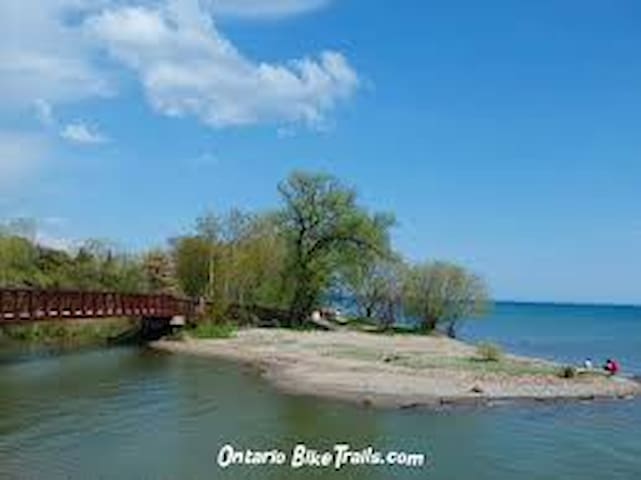
Waterfront Trail
Waterfront TrailThe *** AJAX *** Waterfront Trail is made up of an interconnected series of trails mainly along the shores of Lake Ontario in Canada, beginning in Niagara-on-the-Lake, Ontario and extending to Brockville, Ontario, with an extension along Former Highway 2, to the Quebec provincial border.